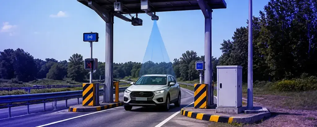
Full FREEFLOW electronic toll collection infrastructure engineered for tomorrow’s highways[cite: 6].
FREEFLOW: No Stop, No Delay
FREEFLOW architecture eliminates traditional toll barriers entirely, allowing vehicles to pass at highway speeds without interruption[cite: 6].
This approach dramatically reduces congestion, improves fuel efficiency, and creates a seamless travel experience while maintaining precise billing accuracy[cite: 6].
Key Infrastructure Capabilities:
- Multi-sensor vehicle detection and classification[cite: 6]
- High-accuracy INVIS ANPR camera integration[cite: 6]
- Real-time data processing and verification[cite: 6]
- Scalable, future-ready system architecture[cite: 6]
Zero Stops
Vehicles transit at full speed—no queuing, no booths, no delay[cite: 6].
High Throughput
Dramatically higher traffic flow compared to barrier-based networks[cite: 6].
24/7 Operation
Fully automated system operates continuously across the corridor without manual intervention[cite: 6].
Core Technology Stack
INVIS solution integrates four complementary sensor technologies, each playing a distinct role in building a complete, high-confidence picture of every vehicle passing through the corridor[cite: 6]:
INVIS ANPR Cameras
Automatic Number Plate Recognition cameras capture license plate data with exceptional accuracy in all weather conditions and lighting environments—day and night[cite: 6].
AVC Sensors
Automatic Vehicle Classification sensors categorize vehicles by axle count, height, and physical dimensions to ensure accurate toll class assignment[cite: 6].
LIDAR Technology
Light Detection and Ranging provides precise 3D profiling of each vehicle, enabling highly accurate measurements and improving overall detection reliability[cite: 6].
RFID Readers
Radio Frequency Identification readers instantly communicate with onboard transponders, enabling seamless electronic payment and vehicle identity verification[cite: 6].
How the System Works: End to End Flow
From the moment a vehicle enters the detection zone to the final billing confirmation, the entire process takes milliseconds[cite: 6]. Each sensor layer feeds into a central processing engine[cite: 6].
Detection
Classification
Verification
Billing
INVIS ANPR: Precision at Highway Speed
The INVIS ANPR camera system is the visual backbone of the entire platform[cite: 6]. Designed for high-speed roadway environments, these cameras deliver reliable character recognition across a wide range of challenging conditions[cite: 6].
All-Weather Performance
Optimized for rain, fog, direct sunlight, and complete darkness—ensuring consistent read rates year-round regardless of environmental conditions[cite: 6].
Multi-Lane Coverage
Strategically positioned cameras provide full-width gantry coverage, capturing every vehicle in every lane simultaneously without blind spots[cite: 6].
Real-Time Processing
Onboard image processing delivers plate recognition results in real time, feeding directly into the central transaction engine for immediate cross-validation[cite: 6].
LIDAR + AVC: Accurate Vehicle Profiling
LIDAR: 3D Vehicle Geometry
LIDAR sensors emit thousands of laser pulses per second to generate a precise three-dimensional profile of each passing vehicle[cite: 6]. This spatial data confirms vehicle dimensions (length, height, and width) with centimeter-level accuracy, making it nearly impossible to misclassify a vehicle or circumvent toll charges[cite: 6].
AVC: Axle-Based Classification
Automatic Vehicle Classification sensors detect wheel contact and axle groupings to assign each vehicle to the correct toll class[cite: 6]. Combined with LIDAR geometry data, the system reliably distinguishes between motorcycles, passenger cars, light commercial vehicles, trucks, and multi-axle freight vehicles[cite: 6].
System Architecture Built for Reliability
The integration of four independent sensor streams into a single cohesive platform[cite: 6]. Each technology acts as both a primary data source and a validation layer[cite: 6].
INVIS ANPR CameraPlate Recognition
AVC SensorVehicle Classification
Central Processing Engine
LIDAR Technology3D Profiling
RFID ReaderTransponder Verification
Transaction Output
This redundant, multi-modal architecture ensures that even if one sensor encounters an anomaly, the system maintains high transaction accuracy by cross-referencing the remaining data streams[cite: 6].
Why INVIS for Smart Cities
Traffic Intelligence
Real-time vehicle count, speed, and classification data supports dynamic traffic management and long-term infrastructure planning decisions[cite: 6].
Scalable Platform
The open architecture is designed to integrate with broader smart city ecosystems—including variable message signs, incident detection, and national mobility platforms[cite: 6].
Sustainable Mobility
Eliminating toll stop-and-go traffic reduces vehicle emissions, fuel consumption, and noise pollution across the corridor—contributing directly to sustainable infrastructure goals[cite: 6].
INVIS
WWW.INVIS.COM.TR